Adventures in Olympic National Park
January 10-14, 2003See the complete photos!
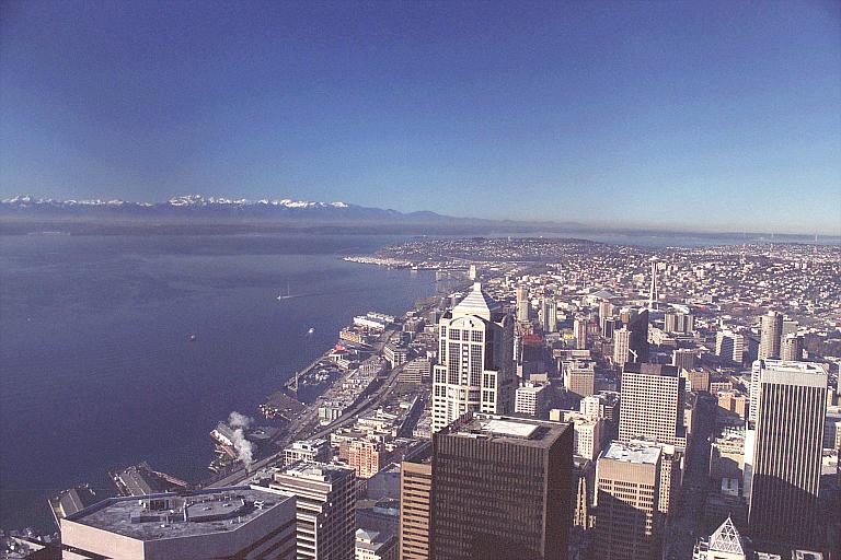 The view from the top of the Bank of America Building looking NW over Seattle. The Olympics are those big, snowy mountains on the horizon. |
 OK, so January is hardly peak tourist season in the Pacific Northwest, but we didn't have much choice. Amy and I were flying out to Seattle to attend the 201st Meeting American Astronomical Society from the 6th through the 9th. I've been to a number of these meetings before in less interesting locations (Washington, DC, Atlanta, etc) and they've always been a good opportunity to see what the community is up to and hear about new discoveries. Mostly it's a reunion with old college and grad school friends and a chance to run up resturant bills on the grant. This time I had the added goal of hob-nobbing with potential employers and fishing about for a job. This turned out very well. Afterward, we rented a car and spent a few days exploring nearby stuff.
I was lead to believe that Seattle was cold and rainy much of the time. Much to our surprise, the skies were crystal clear and the temperatures were in the comfortable 40s and 50s for all five days of the meeting. We spent quite a while walking around the city, made a pilgrimage to the flagship REI store, climbed the pinacle, rode the monorail, saw the Space Needle, and enjoyed various interesting and delicious food in the city. The conference went well and I picked up several job leads. I gave a 15 minute talk about my thesis research which was fairly well recieved.
Friday - after a leisurely morning spent recovering from the exhausting meeting, we packed up, headed to the airport and picked up our rental car. An hour later we were parked on the large ferry steaming across Puget Sound headed for the Peninsula. Mount Rainier and Mount Baker stood out on the eastern horizon looming and massive. The rugged Olympic range stood to the west looking snow-bound and enticing. Without much ado, we docked and drove west on US101 for several hours. Our goal for the weekend was the small town of Forks, WA, (pronounced 'Farks') situated on the western side of Olympic National Park. Along the way, we stopped in Sequim (pronounced 'Skwim'), and Port Angeles, two of the largest towns on the peninsula. These towns are located only about 20 miles apart, but Sequim is in the rain shadow while point west are not. The difference is more than academic. Wet air from the Pacific moves east and cools as it climbs the rugged Olympic mountains. As it cools, huge quantities of rain falls on the western slopes leaving the east quite dry. Sequim gets a paltry 17 inches of rain per year while someregions on the other sides of the mountains get nearly 170 inches! As soon as we crossed the rain shadow line, the woods became lush and dense. The beautiful Crescent Lake featured impenetrable forest, thick moss and a palisade of mountains guarding it from all comers. It was a very pleasent drive. We arrived in Forks just as darkness fell. It's a small town with what looks like a fairly active tourist trade; hikers in the summer, fishermen in the early spring.
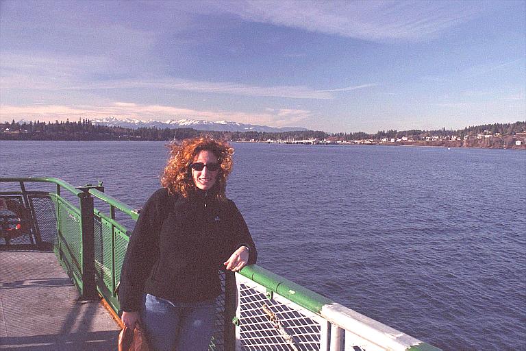 Our ferry pulls into port on the Olympic Penninsula |  The lovely Lake Crescent on scenic US101. |
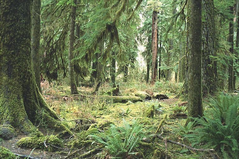 Part of the aptly-named Hall of Mosses |
Along the way we stopped at one of the largest Sitka spruce trees in the world. It stands 200+ feet tall and is 12 feet in diameter at about chest level. Little did we know that this gargantuan tree was only a harbinger of things to come. When we disembarked at the visitor's center and hit the trails, we were surrounded by gigantic trees. We warmed up on the spectacular Hall of Mosses loop trail winding through towering trees covered in moss, ferns and lichen on every surface. We became numb to it after a while. Every now and then, a fallen tree blocked the way and had been chain-sawed. These cross-sections were often difficult to see over, even from my 6'2" perspective. Older fallen trees were covered in vegetation and were serving as 'nurse logs' for younger trees. Young trees would grow along the tops of the fallen logs deriving nutrients from them as they decayed. It was interesting to see that even some of the biggest trees were growing in suspiciously straight rows, products of the same long-vanished nurse log. Amazing place!
After the 1 mile Hall of Mosses Trail, we set out for a longer walk down the linear Hoh River Trail. This trail follows the river up towards its source at the glaciers on Mount Olympus 20-some miles beyond the trail head. Setting out briskly, we crossed a bridge over a small creek. As I stepped onto the bridge, there was a great splashing and thrashing from underneath and several large salmon swam out from under it. The water was no more than six inches deep and the fish were probably 20" long. They were rather rough looking, leperous individuals and weren't smelling at their best. Clearly, these geriatric fish did not have long for the world.
The trail continued at a nearly level grade frequently on boardwalks or packed-gravel. The forest was not as dense or lush as the Hall of Mosses, but still extremly verdent and humid. Several fallen trees blocked the path here and there. Most were small enough to step over or detour around, but one giant was probably eight feet in diameter and had not yet been chainsawed by the powers that be. This would present a serious problem! Fortunately, the tree had fallen with sufficient force that it cracked and splintered longitudinally. We were able to climb up one split, haul ourselves over the main trunk and then descend via a series of smaller trees which had been knocked over by the larger lumber. Very exciting and wonderful smelling.
We hiked for an hour or so stopping for photos here and there before reaching a lunch spot on a large gravel bar in the middle of the Hoh River. Soon afterward, about a dozen folks arrived with fishing gear. Apparently it was a class in fly fishing tought by someone from a local university. Prime steelhead season was upon us and these folks had turned out in droves. Amy and I continued on to the 3 mile mark before turning around.
What had started as an arbitrary turn-around point turned out to be quite rewarding. Two small but lovely waterfalls appeared unhearalded on the northern side of the trail while, to the south-east, Tom's Creek flowed into the Hoh. Up its valley we caught a glimpse of a lofty, icy peak... probably Mt. Tom on the flanks of Mt. Olympus. As we returned to the car, the weather decided to get an early start on its rich rain quota for the year. We were soon quite damp and, though we were carrying rain gear in abundance, we never bothered to stop and put it on. We arrived at the car footsore and sodden but quite happy with the state of affairs.
Saturday and Sunday nights we lodged at the Miller Tree Inn B&B in Forks, a lovely B&B run by Bill and Susan Brager. Each room has its own theme as well as a gas fireplace. We retired to the hot tub and then relaxed by the fire; a good end to a long day.
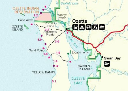 Sunday we awoke much relaxed and enjoyed a scruptious breakfast of French Toast and fruit prepared by our hostess. The weather was looking better than the intermittant rain of Saturday, so we elected to head for the coast. After about an hour of driving on increasingly secondary roads, we came to the Lake Ozette ranger station near the lake of the same name. This is a coastal part of the Olympic National Park and the nearest habitation had been about ten miles back on the road. From here, it is possible to do a 9+ mile hike out to the ocean and back.
Our route took us 3 miles west over boardwalks through rainforest. After our experiences of yesterday, these trees seemed quite homey and of comfortable size. Still, many were four or five feet in diameter which is significantly larger than I am used to! We walked a continuous 3 miles on nicely-maintained boardwalks through dense forest and the more open Ahlstroms Prairie. Some of the boardwalks were made of cedar planks and some of the planks were 30" wide. They were all extremely slippery!
Sunday we awoke much relaxed and enjoyed a scruptious breakfast of French Toast and fruit prepared by our hostess. The weather was looking better than the intermittant rain of Saturday, so we elected to head for the coast. After about an hour of driving on increasingly secondary roads, we came to the Lake Ozette ranger station near the lake of the same name. This is a coastal part of the Olympic National Park and the nearest habitation had been about ten miles back on the road. From here, it is possible to do a 9+ mile hike out to the ocean and back.
Our route took us 3 miles west over boardwalks through rainforest. After our experiences of yesterday, these trees seemed quite homey and of comfortable size. Still, many were four or five feet in diameter which is significantly larger than I am used to! We walked a continuous 3 miles on nicely-maintained boardwalks through dense forest and the more open Ahlstroms Prairie. Some of the boardwalks were made of cedar planks and some of the planks were 30" wide. They were all extremely slippery!
 The sun came out as we neared the ocean. |
Just when the boardwalks were starting to get old, we emerged into a more open, towering, coniferous forest with sunbeams coming in through the opennings in the canopy. A muted roaring sound could be heard ahead and before long we could see the Pacific stretching out a small fraction of its 8,000 mile breadth toward Japan. We decended on a grassy path past a few campsites and were soon on a rocky, kelp-strewn beach. Sea-stacks of various sizes could be glimpsed in the foggy distance out to sea and various sea birds were busily hunting for food amongst the kelpy rocks revealed by the low tide. (Tide is important on this hike as certain portions are impassible during high tides.) We ate lunch, basked in the sun, and then started south.
Beach walking is arduous work. The loose gravel and sand shifted out from under our boots and the going was slow. Furthermore, we were walking directly into the low-elevation sun so the best views tended to be behind us. Still, our environment was completely different from the rainforest of yesterday or even the hiking of the morning. Huge driftwood logs lay cluttered here and there against the bankings where more lively trees of similar size marched all the way down the bankings to meet them. Giant kelp fronds looking like Indiana Jones-style bull whips cluttered the place attracting flies. Frequent fresh-water rivulets emerged from the forest and cut temporary drainage patterns through the soft sand. The surf was far out to our right crashing against low-tide rocks and the day was getting hot (for January at 48 degrees north!).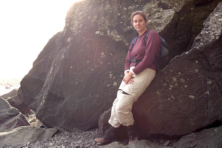 Amy with the petroglyphs. Pictured are two orcas, the sun and the moon. On the rock she's sitting on is a fainter whale of a different species. |
The three miles of beach are interupted twice (roughly at the one and two mile marks) by trails which leave the beach and bypass treacherous headlands. These are marked by large circular black-and-orange quadrant signs which it is important to keep an eye out for. The first of these, Wedding Rocks, was a steep climb around a small headland under some impressive cliffs. After a concerted search, we found the Native American petroglyphs carved on some of the smaller rocks and many photos were taken. There are supposedly quite a few of these carvings, but I only found a few examples. The best was a pair of Orcas and a pair of smiling faces (perhaps the sun and moon?). There was also a mushroom shape with a smily face on it. Very intriguing!
The second headland was bypassed by an extremely steep scramble up the side of a future sea stack. Some kind soul had rigged a large rope from a tree on top to aid in the loose-dirt scramble. The rope has seen better days and left manilla splinters in my palms. Still, the view from on top was spectacular. A similar rope lead down the other side and back to the beach. Looking north along the coast from near Sand Point. |
After another half mile or so, we reached the gorgeous Sand Point, the third headland where the return trail started. There was a little confusion as to where the trail actually was since a large orange-and-black trail marker on a tree was paired with a trail-closed sign. We continued on a few hundred yards and climbed the steep trail to the grassy top of a proto-sea stack for another spectacular view. To the south, the beach continued windswept, deserted and completely wild. Instead of the rocky tide-pools that had characterized the coast to the north, there was actual sand with actual breakers! Too bad the hour was late and we were quite footsore already. But spied another trail sign south of Sand Point and made for it.
The transition from beach to forest was sudden and complete. One minute you're walking on soft sand, avoiding kelp and driftwood and the next you're striding through dim evergreen forest with thick shrubbery on all sides. The sun had been lowering while we were on the beach and filtered through the high branches, it was almost hard to see. My ankle had started to hurt again, but we kept up a quick pace for home before it got dark. Three more miles of boardwalk passed somewhat painfully and we each had a slip on the slick boards.
The sun set with half a mile to go and we limped into the parking lot at something like 5pm. The drive back was dark and uneventful. We gorged on pizzas in Forks and retired to our room at the B&B quite tired and satisfied with life.Monday we bid adieu to Forks and headed east on the first leg of our trip home. Despite being tired from the previous hiking, we stopped for two short hikes to see the Sol Duc waterfall and Merrymere Falls, both near the impressive Crescent Lake. Of the falls, the first was the more impressive and interesting; a stream fell through four channels along the left side of a 40' deep, moss-covered canyon. Merrymere Falls was also pretty, but was a simple 90' falls into a small pool. We continued on having a late lunch in a great cafe in Port Angeles. The rest of the trip back was without incident.
All in all, a very nice trip with some much-needed relaxation and perspective.
 The Wilderness Journal |  Neithernor |